Look up soil profiles for any golf course in the United States
I put together a web app that pulls soil properties for any golf course in the United States. Enter your golf course and see maps with drainage, water infiltration, soil texture, and more.
Example golf course
Let’s look at Pebble Beach. Search for Pebble Beach Golf Links in the search bar and select it from the dropdown. The map draws a course boundary and loads soil polygons.
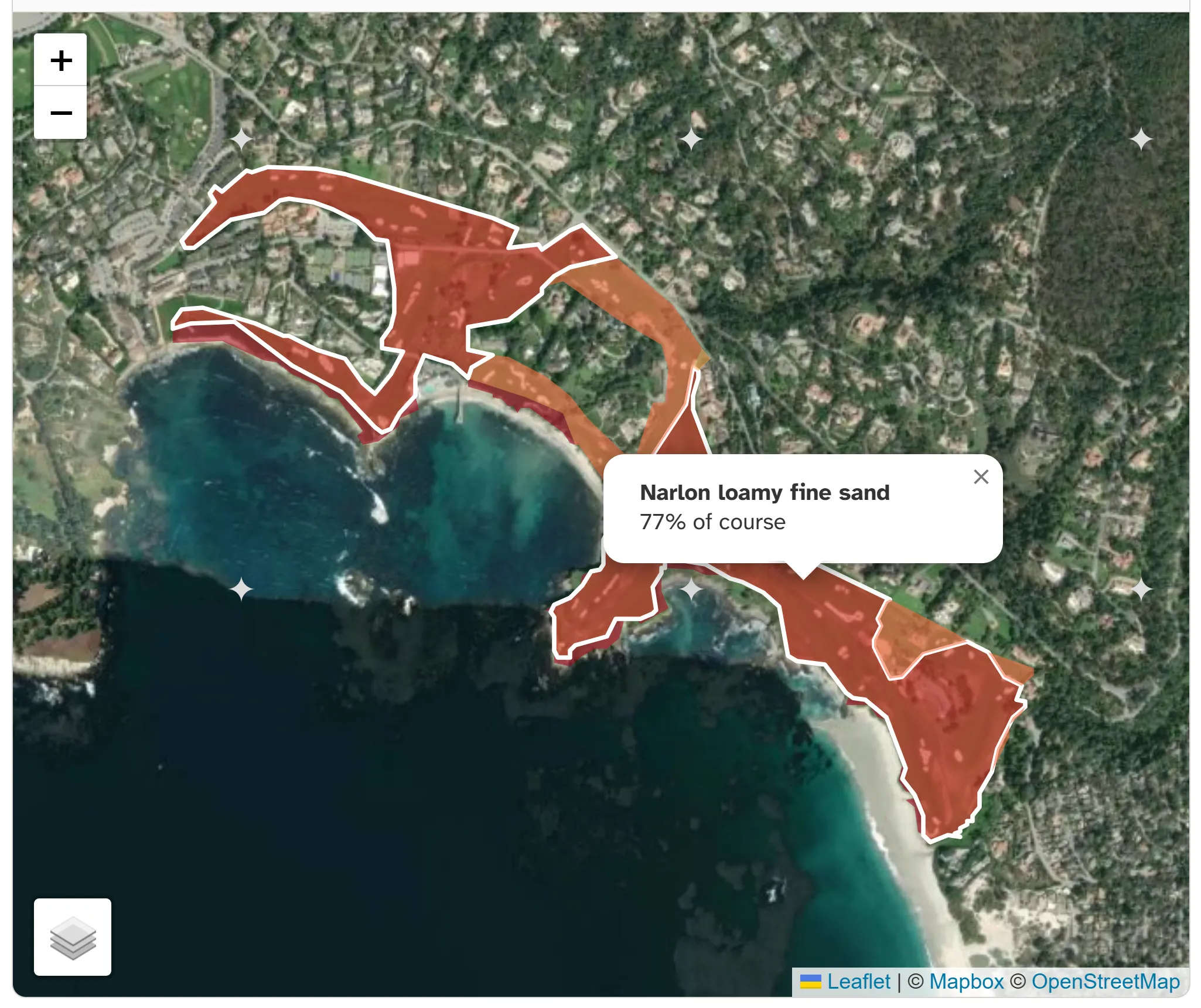
We can see Pebble Beach has 4 soil types across the course. Most of the property is covered by Narlon loamy fine sand. Holes 4, 5, 15, and 12 are a swath of sandy soil called Baywood sand, and there are strips along the ocean where the soil is classified as coastal beaches.
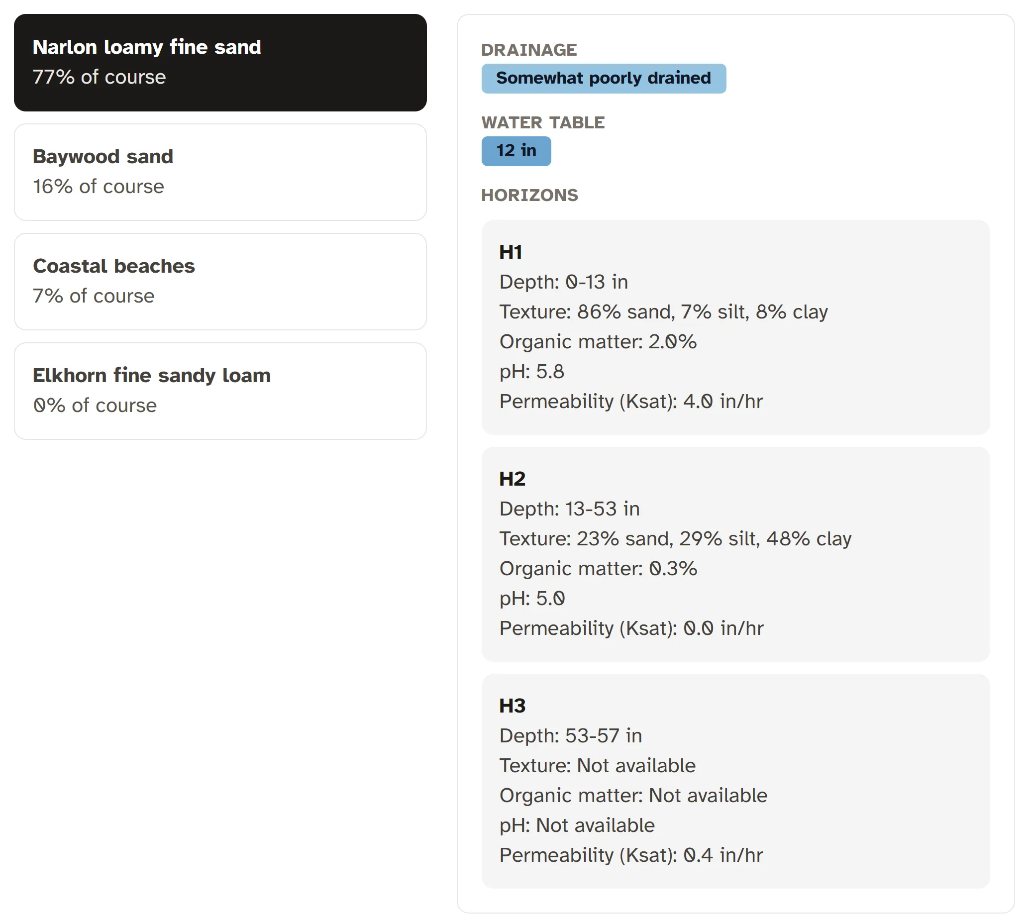
Look at the detailed horizons in the screenshot above. The loamy fine sand covers 77% of the property, and texture changes with depth. The top layer (H1) is 86% sand down to a depth of 13 inches. Below that, the next layer is 48% clay. There is about one foot of sand sitting over three feet of clay. Sand-over-clay dynamics are important for hydrology and drainage behavior.
How to use soils data
Drainage
Some say drainage is the single most useful field for understanding water movement on a golf course. The USDA-NRCS soil database uses 7 drainage classes, and most golf course soils fall into well drained or moderately well drained. Those 2 drainage classes make up 62% of all golf course soils. That makes sense—you wouldn’t be able to grow grass without adequate drainage. Poorly drained areas can still show up, but they’re often found out of play. Look at Broad Bay Country Club in Virginia Beach, for example.
Soil texture
Sand, silt, and clay percentages impact soil water movement and nutrient holding capacity. Sandy soils drain fast and hold fewer nutrients. Clay soils hold water and nutrients, but can compact and restrict root growth. The sandiest golf courses are concentrated in Florida, and the highest-clay courses cluster in parts of Texas.
Permeability (Ksat)
Ksat (saturated hydraulic conductivity) measures how quickly water moves through saturated soil. It’s a way to think about permeability. High Ksat soils pass water quickly. Low Ksat soils transmit water slowly. Ksat is useful for understanding runoff during rain events. Certain parts of a golf course accept water quickly while others stay wet or shed water during rain.
Water table
Water table depth is how far down you’d hit standing water if you dug a hole. There are golf courses with shallow water tables a few feet deep. In some cases, water can move upward into the soil and give turfgrass roots access to water without as much overhead irrigation. Check out Goose Creek Golf Club in California for a high water table. The water table range means it fluctuates seasonally. Water table data is not available for all golf courses, or may be partial for a given golf course.
Caveats
This data represents native soils. Golf courses can be heavily modified: greens are constructed with sand profiles, fairways get topdressed, drainage is installed. Your golf course conditions can differ from what’s shown here, especially in the top 4 to 6 inches. Even so, the native soil profile still explains the underlying drainage and water behavior of the site.